Toronto sits on a complex mix of glacial till, Lake Iroquois clay, and urban fill. The water table is often shallow, especially near the lake shore. This makes resistivity surveys a practical first step for subsurface mapping. We use vertical electrical sounding (VES) to identify lithology changes and groundwater depth without drilling. Before mobilizing a drill rig, a resistivity profile can reveal hidden sand lenses or bedrock channels. When combined with ensayo CPT data, the interpretation becomes far more reliable for foundation design.
Glacial till and clay-rich soils in Toronto produce resistivity contrasts as low as 5–20 Ω·m, demanding high-resolution inversion routines.
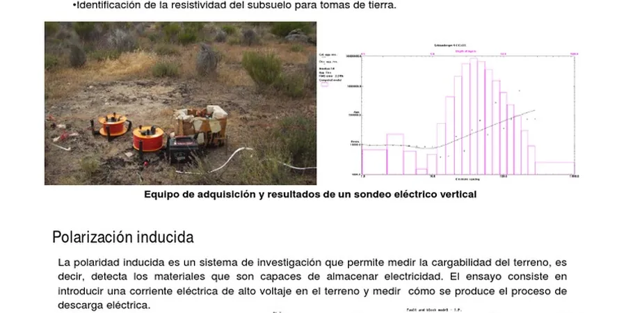
Methodology and scope
The city spans roughly 630 km² and sits on a Paleozoic limestone bedrock that dips southward. Glacial processes left a variable overburden thickness, from zero bedrock outcrops in the north to over 60 meters of clay in the south. Resistivity surveys in Toronto must account for high clay content, which lowers bulk resistivity. Urban infrastructure — buried utilities, subway tunnels, steel pipes — creates noise that requires careful electrode layout. We follow ASTM D6431 for array selection and data inversion. A typical survey covers 200 to 500 linear meters per day. For deeper targets, we recommend estudio de mecanica de suelos as a correlative tool to calibrate resistivity models with actual soil samples.
Technical reference image — Toronto
Local considerations
A mid-rise project near Yonge and Eglinton encountered unexpected wet sand lenses at 12 m depth. The geotechnical report assumed uniform glacial till based on two boreholes. A resistivity survey would have caught the anomaly. The result was a costly foundation redesign. In Toronto, shallow groundwater and fill from past industrial uses create hidden variability. Resistivity surveys reduce that risk at a fraction of the cost of additional boreholes. They also map contaminant plumes and buried debris before excavation begins.
1D depth profiling using Schlumberger array. Ideal for estimating overburden thickness, locating bedrock, and identifying aquifers. Each sounding takes 1–2 hours in urban settings.
02
2D Electrical Resistivity Tomography (ERT)
Continuous multi-electrode profile along linear alignments. Used for mapping lateral soil changes, buried channels, and groundwater pathways. Outputs a georeferenced resistivity section up to 80 m deep.
Applicable standards
ASTM D6431-18 (Standard Guide for Using the DC Resistivity Method), ASTM D6429-20 (Standard Guide for Selecting Surface Geophysical Methods), Ontario Regulation 903 (Water Wells — logging requirements for resistivity)
Frequently asked questions
What is the difference between VES and 2D ERT?
VES provides a 1D resistivity model beneath a single point, assuming horizontal layers. 2D ERT uses multiple electrodes along a line to produce a cross-section. ERT is better for detecting lateral variations like sand channels or bedrock pinnacles common in Toronto's glacial deposits.
How deep can a resistivity survey reach in Toronto?
With a 200 m AB/2 spacing using the Schlumberger array, depth penetration reaches approximately 40–60 m in clay-rich soils. For deeper targets, 400 m spacing can reach 80–100 m, though resolution degrades below 60 m due to signal attenuation in conductive clay.
How much does a resistivity survey in Toronto typically cost?
For a standard VES survey at 5 to 10 stations, the cost ranges between CA$790 and CA$1,480. This includes mobilization within the GTA, data acquisition, inversion, and a report with interpreted depth sections. Larger 2D ERT lines cost proportionally more.
Can resistivity surveys detect contaminated soil or groundwater?
Yes. Contaminants like chlorinated solvents or landfill leachate alter pore fluid conductivity. Resistivity surveys can map plumes with contrasts as low as 5 Ω·m. In Toronto, this is useful for brownfield redevelopment along the waterfront and former industrial lands.
Location and service area
We serve projects across Toronto and its metropolitan area.